Showing posts with label geography. Show all posts


Even as awareness around plastic pollution grows, very little is being done to solve the problem. At this rate, by 2050, some experts predict the world's oceans will contain more plastic than fish.

A think piece from the United Nations, commissioned by the G20, has now detailed everything the world should do to stop that from becoming our reality because we're not doing enough.

Today, roughly 11 million tonnes of plastic end up in our oceans each year, and according to a 2020 model from SYSTEMIQ and The Pew Trusts, by 2040, the amount of plastic waste that leaks into our oceans could nearly triple.

Meanwhile, promises and policies from governments and companies will only reduce plastic litter in the marine environment by 7 percent.

That's nowhere near what will be needed to achieve the G20's Osaka Blue Ocean Vision, which seeks to stop any new plastic pollution from entering the oceans by 2050.

To get there, researchers at the UN argue the world needs a "wholesale change in the plastics economy". We need the plastics industry to go from a "linear and wasteful system" to a circular and renewable one in just a few decades.

According to the report, that's a lofty goal, but it's the only way to achieve the Osaka Blue Ocean Vision. If the G20 is really serious about its commitments, then leading nations need to make plastic pollution a bigger priority going forward.

The report is largely reliant upon a model published in 2020. It shows that if the world does decide to take ambitious and urgent action on plastic pollution, we can reduce the litter destined for our oceans by 82 percent come 2040 using known technology and approaches.

That will, of course, require nations from all around the world to act in unison, something we haven't been great at so far. But if we can figure out the best route to get there, we could create a road map for all to follow.

"It's time to stop isolated changes where you have country after country doing random things that on the face of it are good but actually don't make any difference at all," says Steve Fletcher from the University of Portsmouth. 

"Intentions are good but don't recognize that changing one part of the system in isolation doesn't magically change everything else."

Recycling alone won't be enough. The 2020 model found at least half a million people will need to be connected to waste collection services every day for that to work as a strategy. 

"Given this is unlikely, reducing the amount of plastic in the system should be a top priority for policymakers because waste management systems cannot scale quickly enough," the report argues.

"The use of plastic can be reduced, minimized, or avoided entirely in many circumstances through intentional design changes to a product."

Global packaging, the authors point out, is valued between $80-120 billion USD per year, yet 95 percent of that money is lost as plastic waste. Not only could changing the design save companies money, but there are also economic benefits that come from developing new products which rely less on plastic and more on renewable materials.

Ocean clean-up efforts will also be necessary to pick up at least part of what we have already tossed away, including the enormous Pacific garbage patch and other similar accumulations of plastic.

But preventing further leakage should be our number one priority, researchers say. Cleaning up plastic in the ocean comes with a lot of challenges, requires advanced technology, and costs a lot of money.

As such, ocean clean-ups should only be considered a "useful transitional effort" on our way to a circular plastics economy. Otherwise, we'll just keep giving ourselves more and more garbage to chip away at.

In a time of global economic recovery, when COVID-19 stimulus packages emphasize green growth like never before, the world has an opportunity to address the plastics economy like never before.

If these stimulus packages can include measures to reduce marine plastic and create greener sectors from nation to nation, we might just make the Osaka Blue Ocean Vision come true after all.

The UN International Resource Panel report is available here.


Rocks aren't all created equal. Some of them are heavy, while others are light. Others are black, while others are nearly white. Even igneous rocks generated from magma in the Earth's mantle can have a wide range of appearances.

Igneous rocks

Igneous, sedimentary, and metamorphic rocks are the three main types of rocks. Magma in the Earth's mantle creates igneous rocks. They normally don't include fossils, don't react with acids, don't have visible strata, can be comprised of a variety of minerals, have holes or bubbles, and can appear glassy. Volcanologists search for these igneous rocks in order to understand more about their origins and whether they were generated during a volcanic eruption.

Geologists use the visual appearance of the rock as an initial clue to its composition but will then verify their ideas using specialised techniques. For example, scientists at The University of Auckland use an electron microprobe to measure the exact quantities of silica, iron, magnesium and many other chemicals that are in rock samples they collect. This information helps them to classify the rock and may give them direct clues about the volcano and the eruption that formed the rock.

Nature of science

Classification helps scientists organise things into groups. In rock classification, such grouping can help geologists see patterns and perhaps explain the reasons for rocks looking similar.

Lava solidifies to rock

New Zealand has three main types of volcanoes, and each has been formed from a different type of magma. Once the lava has erupted, it cools and solidifies into rock:

  • Basalt magma often forms shield volcanoes.

  • Andesite magma often forms cone volcanoes.

  • Rhyolite magma often forms calderas. Depending on how much gas the magma contains, it can also form cone volcanoes.

Basalt

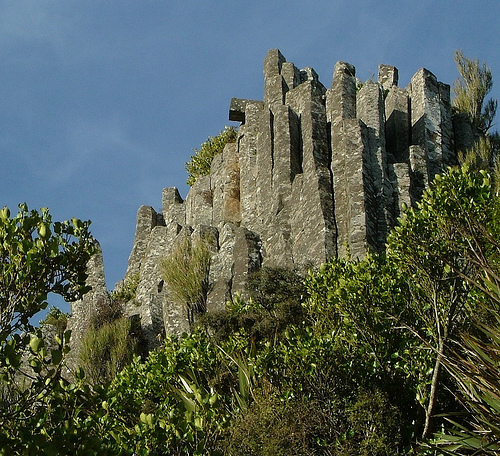
The Earth’s crust is mainly basalt rock. It is a heavy, dark, grainy rock. Basalt is associated with great rock columns that are found in many places around the Earth, for example, the Organ Pipes in Dunedin or the Giant’s Causeway in Ireland.

Rights: Peter MacMurchy

Columnar basalt

Basalt is associated with great rock columns that are found in many places around the Earth, such as the Organ Pipes near Mt Cargill, Dunedin.

Basalt magma is formed at high temperatures (around 1,200ºC). When it comes out of the volcano, it is hot and liquid. It contains very little silica (less than 50%) and a lot of magnesium and iron, which makes the rock look dark.

The Auckland volcanic field has erupted this type of hot, runny iron-rich lava, and the landscape is dotted with mountains made from basalt and scoria (a red-coloured rock that contains large amounts of iron-rich minerals). Both rock types are excavated for building materials and landscaping.

Andesite

Andesites are lighter coloured than basalt because they contain less iron and more silica (50–60%). Some scoria rocks fall within the andesite classification because of their chemical composition.

Rights: The University of Waikato

Andesite

This andesite rock is from the central North Island of New Zealand.

Magma that contains andesite is generally around 800–1,000ºC and forms steep-sided cone volcanoes (stratovolcanoes). Mount Ngāuruhoe is an example of an andesite volcano.

Rhyolite

Rhyolite is light-coloured or white – this is a clue that the rock contains a lot of silica (more than 70%) and not much iron or magnesium.

Rights: Hannes GrobeCreative Commons 2.5

Pumice

Pumice, a rhyolite, is very common in the central North Island. It may still have evidence of the bubbles of gas trapped as the rock solidified.

Rhyolitic magmas are associated with low temperatures (750–850ºC) and are often thick, which means gases can’t escape. Some rhyolitic rocks are quite light, for example, pumice, which may still have evidence of the bubbles of gas trapped as the rock solidified.


Geoengineering schemes are projects designed to tackle the effects of climate change directly, usually by removing CO2 from the air or limiting the amount of sunlight reaching the planet's surface. Although large-scale geoengineering is still at the concept stage, advocates claim that it may eventually become essential if the world wants to avoid the worst effects of climate change. Critics, by contrast, claim that geoengineering isn't realistic – and may be a distraction from reducing emissions.

The first category of scheme – those designed to remove CO2 from the air – include machines (sometimes called "artificial trees") that pull the gas from the atmosphere using plastic polymers. Other proposals seek to increase the amount of CO2 absorbed by the oceans – for example by adding large quantities of lime to the water.
Other related schemes – sometimes but not always described as geo-engineering – involve harnessing the capacity of trees and plants to absorb CO2 from the air. These include burning large quantities of wood in power plants with carbon-capture technology; making and burying large amounts of charcoal to lock carbon into the soils; and grazing cattle in a way designed to turn grasslands into giant carbon sinks.
In the second category – schemes designed to reduce the amount of sunlight reaching Earth – proposals include firing sulphate aerosols into the stratosphere to reflect sunlight back to space; using unmanned ships to increase above-ocean cloud cover by spraying sea water into the air; painting the world's roofs white to increase reflectivity; and even floating thousands of tiny mirrors in space between Earth and the sun.
Some geoengineering schemes, such as adding aerosols to the stratosphere, have attracted heavy criticism for their possible side effects. Even if these side-effects weren't severe, schemes that "mask" the temperature rise rather than removing the CO2 come with some serious disadvantages, such as the fact that they don't deal with CO2's other major impact: ocean acidification. Administering any such scheme would also raise obvious issues of geopolitics and global governance.
Other schemes, such as the machines designed to suck CO2 directly out of the air, are far less controversial, since all they aim to do is remove a pollutant that humans are adding to the air. The main challenges in this case are reducing manufacturing and running costs to make the devices commercially viable, and finding reliable and inexpensive ways to store the captured gas.

Earth_experiences_an_ice_age_every_100,000_years

Earth is in a pretty unique state of climate change at the moment, but for the past 1 million years, almost like clockwork, our planet has moved in and out of an ice age every 100,000 years.
The only problem is, researchers have never really been able to figure out why. In fact, they've been so puzzled by the mysterious phenomenon, they've labelled it the '100,000 year problem'. But now a new study might finally have the solution.
New research suggests that our oceans might regularly suck more CO2 out of the atmosphere every 100,000 years, allowing the planet to get cold enough to trigger an ice age.
The '100,000 year problem' stems from the fact that around 1 million years ago, Earth started experiencing ice ages - vast ice sheets covering North America, Europe, and Asia - every 100,000 years.
Before this point, which is known the mid-Pleistocene transition, our planet's ice ages used to occur at intervals of every 40,000 years, which made a lot more sense to scientists.
That's because Earth's angular tilt also wobbles in a 40,000 year cycle, which means every 40,000 years, the planet experiences colder than usual summer months because of the way it's tilted towards the Sun.
That variation in Earth's tilt made the 40,000 year ice ages make sense - but, until now, no one has been able to explain what happened at the mid-Pleistocene transition to overhaul this natural cycle and put our Earth on a 100,000-year schedule instead.
Now researchers have stumbled on a new planetary cycle, and suggest the shift could be a result of our oceans regularly sucking more CO2 out of the atmosphere.
"We can think of the oceans as inhaling and exhaling carbon dioxide, so when the ice sheets are larger, the oceans have inhaled carbon dioxide from the atmosphere, making the planet colder," explains lead researcher Carrie Lear from Cardiff University in Wales.
"When the ice sheets are small, the oceans have exhaled carbon dioxide, so there is more in the atmosphere which makes the planet warmer."
It's long been known that our ocean can store carbon, partly through the action of marine algae, which needs to suck up carbon in order to photosynthesise.
To figure out what was going on, the team looked at the fossilised remains of marine algae over the past millennia to see if the rate at which they sucked up CO2 was constant.
They found that there are periods where the algae showed signs of having sucked up significantly more CO2, and, yep, those periods occurred every 100,000 years or so, corresponding with the timing of Earth's ice ages.
The team suggests that the extra CO2 the marine algae was removing from the atmosphere lowered the temperature long enough for large ice sheets to form in the Northern Hemisphere.
After a while, the CO2 would have been naturally released to the surface through a process known as upwelling, but by that point, the ice age would have been in full swing, and the CO2 would have been trapped in the oceans by a layer of ice across most of the planet, keeping Earth colder for longer.
"If we think of the oceans inhaling and exhaling carbon dioxide, the presence of vast amounts of ice is like a giant gobstopper," said Lear. "It's like a lid on the surface of the ocean."
More research is needed to figure out what makes these marine algae suddenly suck up more CO2 every 100,000 years, and additional study will need to verify that this action is enough to trigger an ice age.
But the study provides useful insight into the cycles that affect our planet, and will continue to affect it in the future.
Right now, Earth is in a warm spell between ice ages, with the last ice age ending about 11,000 years ago.
But there's evidence that human-made climate change has already suppressed the next ice age from happening, and experts don't predict that an ice age will be able to occur for at least another 100,000 years - slightly behind schedule.
Hopefully before then, humanity will have found our own way to curb - and even reduce - the amount of CO2 we're pumping out into the atmosphere, so Earth's natural cycles can have a shot at restoring some of the imbalance in our currently climate system.


Mission MapQuest is a great map game creation tool developed by friend Russel Tarr for his ClassTools.net website. The concept behind Mission Mapquest is rather straight-forward one. On Mission Mapquest you create a series of clues that your students need to follow to identify places around the world. You can add as few or as many clues to your MapQuest as you like. When you're ready to have students try your MapQuest just give them the web address assigned to it. Mission Mapquest games are created in HTML5 which means that they can be played on iPads and Android tablets as well as on laptops. Watch the video embedded below to learn how to create your own map-based quizzes on Mission MapQuest.

There is certainly not a shortage of map quiz on games on the Internet. GeoGuessr and Spacehopper have been two of my favorites for a long time. Now I have another to add to my list of favorites. That addition comes in the form of GeoQuiz.

GeoQuiz is a map game that shows you a placemarker on a map. Once the placemarker appears you have to speak or type the name of the country in which the marker was placed. The object of the game is to identify as many countries as possible within 60 seconds.

In my testing of GeoQuiz I had to be sure to enunciate when I said the name of a country. GeoQuiz did a good job of recognizing what I was trying to say, most of the time. Be sure to use the Chrome web browser and enable microphone access in order to play the game.

Applications for Education
GeoQuiz could be a good game for students to play to review their knowledge of the locations of countries around the world. The option to speak a name rather than type it might give some students the opportunity to prove that they know more than they could actually demonstrate by typing.

H/T to Maps Mania. 

My students here in Maine always think of our state as being a big place and it is relative to the rest of New England. Compared to our friends in the west, Maine is a small place. Similarly, they sometimes have trouble understanding the size of the lower 48 states compared to Canada. The following three tools can help students understand the size of their countries in relation to the size of other countries.

If It Were My Home is a neat site that provides comparisons of countries. If It Were My Home will show you a comparison of geographic size of your country with that of another of your choosing. Beyond the size comparison, If It Were My Home shows you comparisons of twelve health and economics statistics about life in different countries. To view the comparisons just select two countries from the lists and click compare.

Overlap Maps is a free service that can be used to quickly compare the size of countries, states, provinces, and some bodies of water. To create a visual comparison of two countries select one country from the "overlap this" menu and select one country from the "onto this" menu. The comparisons you make are displayed on a map. You can make comparisons from different categories. For example, you can overlap Lake Erie onto New Hampshire.

The True Size Of... is a free web tool that lets you quickly compare the size of two countries or two states within the United States. To compare two countries simply enter one into the search box then enter a second one into the search box. Both countries will be highlighted for you. You can then drag and drop one onto the other. The same can be done with states of the United States as is demonstrated in my screenshot below.

Powered by Blogger.