Showing posts with label geophysicist. Show all posts


Rocks aren't all created equal. Some of them are heavy, while others are light. Others are black, while others are nearly white. Even igneous rocks generated from magma in the Earth's mantle can have a wide range of appearances.

Igneous rocks

Igneous, sedimentary, and metamorphic rocks are the three main types of rocks. Magma in the Earth's mantle creates igneous rocks. They normally don't include fossils, don't react with acids, don't have visible strata, can be comprised of a variety of minerals, have holes or bubbles, and can appear glassy. Volcanologists search for these igneous rocks in order to understand more about their origins and whether they were generated during a volcanic eruption.

Geologists use the visual appearance of the rock as an initial clue to its composition but will then verify their ideas using specialised techniques. For example, scientists at The University of Auckland use an electron microprobe to measure the exact quantities of silica, iron, magnesium and many other chemicals that are in rock samples they collect. This information helps them to classify the rock and may give them direct clues about the volcano and the eruption that formed the rock.

Nature of science

Classification helps scientists organise things into groups. In rock classification, such grouping can help geologists see patterns and perhaps explain the reasons for rocks looking similar.

Lava solidifies to rock

New Zealand has three main types of volcanoes, and each has been formed from a different type of magma. Once the lava has erupted, it cools and solidifies into rock:

  • Basalt magma often forms shield volcanoes.

  • Andesite magma often forms cone volcanoes.

  • Rhyolite magma often forms calderas. Depending on how much gas the magma contains, it can also form cone volcanoes.

Basalt

The Earth’s crust is mainly basalt rock. It is a heavy, dark, grainy rock. Basalt is associated with great rock columns that are found in many places around the Earth, for example, the Organ Pipes in Dunedin or the Giant’s Causeway in Ireland.
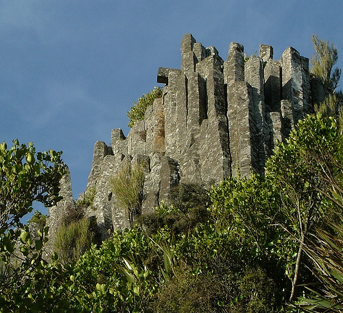
Rights: Peter MacMurchy

Columnar basalt

Basalt is associated with great rock columns that are found in many places around the Earth, such as the Organ Pipes near Mt Cargill, Dunedin.

Basalt magma is formed at high temperatures (around 1,200ºC). When it comes out of the volcano, it is hot and liquid. It contains very little silica (less than 50%) and a lot of magnesium and iron, which makes the rock look dark.

The Auckland volcanic field has erupted this type of hot, runny iron-rich lava, and the landscape is dotted with mountains made from basalt and scoria (a red-coloured rock that contains large amounts of iron-rich minerals). Both rock types are excavated for building materials and landscaping.

Andesite

Andesites are lighter coloured than basalt because they contain less iron and more silica (50–60%). Some scoria rocks fall within the andesite classification because of their chemical composition.

Rights: The University of Waikato

Andesite

This andesite rock is from the central North Island of New Zealand.

Magma that contains andesite is generally around 800–1,000ºC and forms steep-sided cone volcanoes (stratovolcanoes). Mount Ngāuruhoe is an example of an andesite volcano.

Rhyolite

Rhyolite is light-coloured or white – this is a clue that the rock contains a lot of silica (more than 70%) and not much iron or magnesium.

Rights: Hannes GrobeCreative Commons 2.5

Pumice

Pumice, a rhyolite, is very common in the central North Island. It may still have evidence of the bubbles of gas trapped as the rock solidified.

Rhyolitic magmas are associated with low temperatures (750–850ºC) and are often thick, which means gases can’t escape. Some rhyolitic rocks are quite light, for example, pumice, which may still have evidence of the bubbles of gas trapped as the rock solidified.


Earth_experiences_an_ice_age_every_100,000_years

Earth is in a pretty unique state of climate change at the moment, but for the past 1 million years, almost like clockwork, our planet has moved in and out of an ice age every 100,000 years.
The only problem is, researchers have never really been able to figure out why. In fact, they've been so puzzled by the mysterious phenomenon, they've labelled it the '100,000 year problem'. But now a new study might finally have the solution.
New research suggests that our oceans might regularly suck more CO2 out of the atmosphere every 100,000 years, allowing the planet to get cold enough to trigger an ice age.
The '100,000 year problem' stems from the fact that around 1 million years ago, Earth started experiencing ice ages - vast ice sheets covering North America, Europe, and Asia - every 100,000 years.
Before this point, which is known the mid-Pleistocene transition, our planet's ice ages used to occur at intervals of every 40,000 years, which made a lot more sense to scientists.
That's because Earth's angular tilt also wobbles in a 40,000 year cycle, which means every 40,000 years, the planet experiences colder than usual summer months because of the way it's tilted towards the Sun.
That variation in Earth's tilt made the 40,000 year ice ages make sense - but, until now, no one has been able to explain what happened at the mid-Pleistocene transition to overhaul this natural cycle and put our Earth on a 100,000-year schedule instead.
Now researchers have stumbled on a new planetary cycle, and suggest the shift could be a result of our oceans regularly sucking more CO2 out of the atmosphere.
"We can think of the oceans as inhaling and exhaling carbon dioxide, so when the ice sheets are larger, the oceans have inhaled carbon dioxide from the atmosphere, making the planet colder," explains lead researcher Carrie Lear from Cardiff University in Wales.
"When the ice sheets are small, the oceans have exhaled carbon dioxide, so there is more in the atmosphere which makes the planet warmer."
It's long been known that our ocean can store carbon, partly through the action of marine algae, which needs to suck up carbon in order to photosynthesise.
To figure out what was going on, the team looked at the fossilised remains of marine algae over the past millennia to see if the rate at which they sucked up CO2 was constant.
They found that there are periods where the algae showed signs of having sucked up significantly more CO2, and, yep, those periods occurred every 100,000 years or so, corresponding with the timing of Earth's ice ages.
The team suggests that the extra CO2 the marine algae was removing from the atmosphere lowered the temperature long enough for large ice sheets to form in the Northern Hemisphere.
After a while, the CO2 would have been naturally released to the surface through a process known as upwelling, but by that point, the ice age would have been in full swing, and the CO2 would have been trapped in the oceans by a layer of ice across most of the planet, keeping Earth colder for longer.
"If we think of the oceans inhaling and exhaling carbon dioxide, the presence of vast amounts of ice is like a giant gobstopper," said Lear. "It's like a lid on the surface of the ocean."
More research is needed to figure out what makes these marine algae suddenly suck up more CO2 every 100,000 years, and additional study will need to verify that this action is enough to trigger an ice age.
But the study provides useful insight into the cycles that affect our planet, and will continue to affect it in the future.
Right now, Earth is in a warm spell between ice ages, with the last ice age ending about 11,000 years ago.
But there's evidence that human-made climate change has already suppressed the next ice age from happening, and experts don't predict that an ice age will be able to occur for at least another 100,000 years - slightly behind schedule.
Hopefully before then, humanity will have found our own way to curb - and even reduce - the amount of CO2 we're pumping out into the atmosphere, so Earth's natural cycles can have a shot at restoring some of the imbalance in our currently climate system.


massive_crack_threatening_to_cause_an_entire_Antarctic_ continent
An iceberg the size of Delaware is about to break free.
Scientists have been monitoring a fracture in one of the world’s biggest ice shelves, and report that in the last five months alone, it’s grown an extra 22 kilometres (13.67 miles) in length, and now stretches for a total of 130 km (80 miles).
It’s now only a matter of time before a massive chunk of this Antarctic ice shelf - known as Larsen C - breaks free, and then we’ll have the third largest loss of Antarctic ice in recorded history on our hands.
Located on the coast of the Antarctic Peninsula, the Larsen ice shelf is split up into three smaller ice shelves - Larsen A, B, and C. Larsen A and B have already experienced massive declines over the past two decades, and now Larsen C, the biggest of them all, is in a world of trouble itself.
Researchers from Project MIDAS, a British Antarctic Survey that involves teams from several UK universities, report that around 12 percent of the entire Larsen C ice shelf is expected to break off, leaving the exposed ice front at its most retreated position ever.
"Computer modelling suggests that the remaining ice could become unstable, and that Larsen C may follow the example of its neighbour Larsen B, which disintegrated in 2002 following a similar rift-induced calving event," they report in a blog post.
What’s left of the Larsen B ice shelf is widely considered to be on borrowed time, having lost a chunk of ice the size of Rhode Island back in 2002. Remember this?
It now covers an area of 1,600 square kilometres (625 square miles), and is expected to disintegrate by the end of the decade. That’s pretty devastating, when you consider that Larsen B has been stable for at least the past 12,000 years.
The Larsen A ice shelf disintegrated in January 1995, and now Larsen C looks like it’s on its way out too.
Just to give you an idea of how much ice we’re talking about here, Larsen C covers around 55,000 square km (21,235 square miles). That’s 10 times the size of Larsen B, and about half the size of Iceland.
Last year, the MIDAS team published a study in the journal Cryosphere describing how Larsen C is currently melting from the surface and the base, and now its gigantic fracture is cracking at a rate no one could have predicted.
Once the outer edge breaks free, researchers are predicting an iceberg measuring about 6,000 square kilometres (2,316 square miles) - close to the size of Delaware - will fall off into the ocean.
"If this will calve off in the next, say two or three years, the calving front will be retreated very far back, further than we’ve seen it since we were able to monitor this," one of the team, Daniela Jansen from the Alfred Wegener Institute Helmholtz Centre for Polar and Marine Research in Germany, told Chris Mooney at The Washington Post.
"And our theory in this paper was basically that the calving front might become unstable. Once the iceberg has calved off completely, there might be a tendency for the ice front to crumble backwards."
Just to add to Larsen C’s woes, a separate study published in Nature Communications in June found that meltponds have been forming on the surface - something that’s just recently been found by the thousands on the Langhovde Glacier in East Antarctica.
This will only serve to accelerate the disintegration process.
If Larsen C did end up losing all its ice, scientists have predicted that this could raise global sea levels by around 10 cm (3.9 inches).
massive_breaks_ice_crack_threatening_to_cause_an_entire_Antarctic_ continent

But let’s not get ahead of ourselves here. As Mooney points out, a large loss of ice from Larsen C won’t necessarily be a terrible thing for the world’s oceans - not immediately, at least.

"A study earlier this year in Nature Climate Change looked at ice shelves around Antarctica to determine how much area they could lose without ceasing to form their crucial function of buttressing glaciers and holding them back, and found that Larsen C actually has a lot of 'passive' ice that it can lose without major consequences," he says.

The MIDAS team isn’t as optimistic, so unfortunately, we’re left to wait and see when this massive chunk will break off, and what the consequences will be for life on Earth. Watch this space.
sciencealert

Earthquake- Lurking- India-Bangladesh-highway -road-massive-crack

A huge earthquake may be building beneath Bangladesh, which can turn urban areas in eastern India into "ruins", a new study has warned.

Scientists said they have new evidence of increasing strain where two tectonic plates underlie the world's largest river delta.

They estimate that at least 140 million people in the region could be affected if the boundary ruptures; the destruction could come not only from the direct results of shaking, but changes in the courses of great rivers, and in the level of land already perilously close to sea level.

The newly identified threat is a subduction zone, where one section of earth's crust, or a tectonic plate, is slowly thrusting under another.

All of earth's biggest known earthquakes occur along such zones; these include the Indian Ocean quake and tsunami that killed some 230,000 people in 2004, and the 2011 Tohoku quake and tsunami off Japan, which swept away more than 20,000 and caused the Fukushima nuclear disaster.

Up to now, all known such zones were only under the ocean; this one appears to be entirely under the land, which greatly multiplies the threat.

The strain between the plates has been building for at least 400 years - the span of reliable historical records, which lack reports of any mega-quake, said lead author Michael Steckler, a geophysicist at Columbia University.

When an inevitable release comes, the shaking is likely to be larger than magnitude 8.2 on the Richter scale and could even reach a magnitude of 9, similar to the largest known modern quakes, said Steckler.

A giant plate comprising India and much of the Indian Ocean has been thrusting northeasterly into Asia for tens of millions of years, researchers said.

This collision has caused the Himalayas to rise to the north, bringing events like the 2015 Nepal quake that killed nearly 9,000 people.

Bangladesh and eastern India sit atop a landscape vulnerable even to moderate earthquakes: the vast delta of the Ganges and Brahmaputra rivers, researchers said.

This is basically a pile of mud as deep as 12 miles, washed from the Himalayas to the coast, covering the subduction zone.

In a quake, this low-lying substrate would magnify the shaking like gelatin, and liquefy in many places, sucking in buildings, roads and people, said study coauthor Syed Humayun Akhter, a geologist at Dhaka University.

"We don't have a good idea of its geometry, we don't know how far it goes down," said James Ni, a seismologist at New Mexico State University.

He said that if researchers are right, and the slab is building strain, a quake would probably turn urban areas in eastern India "into ruins," and effects likely would extend into Myanmar and beyond.

The findings appear in the journal Nature Geoscience.

Earthquake- Lurking- India-Bangladesh-highway -road-massive-crack

A huge earthquake may be building beneath Bangladesh, which can turn urban areas in eastern India into "ruins", a new study has warned.

Scientists said they have new evidence of increasing strain where two tectonic plates underlie the world's largest river delta.

They estimate that at least 140 million people in the region could be affected if the boundary ruptures; the destruction could come not only from the direct results of shaking, but changes in the courses of great rivers, and in the level of land already perilously close to sea level.

The newly identified threat is a subduction zone, where one section of earth's crust, or a tectonic plate, is slowly thrusting under another.

All of earth's biggest known earthquakes occur along such zones; these include the Indian Ocean quake and tsunami that killed some 230,000 people in 2004, and the 2011 Tohoku quake and tsunami off Japan, which swept away more than 20,000 and caused the Fukushima nuclear disaster.

Up to now, all known such zones were only under the ocean; this one appears to be entirely under the land, which greatly multiplies the threat.

The strain between the plates has been building for at least 400 years - the span of reliable historical records, which lack reports of any mega-quake, said lead author Michael Steckler, a geophysicist at Columbia University.

When an inevitable release comes, the shaking is likely to be larger than magnitude 8.2 on the Richter scale and could even reach a magnitude of 9, similar to the largest known modern quakes, said Steckler.

A giant plate comprising India and much of the Indian Ocean has been thrusting northeasterly into Asia for tens of millions of years, researchers said.

This collision has caused the Himalayas to rise to the north, bringing events like the 2015 Nepal quake that killed nearly 9,000 people.

Bangladesh and eastern India sit atop a landscape vulnerable even to moderate earthquakes: the vast delta of the Ganges and Brahmaputra rivers, researchers said.

This is basically a pile of mud as deep as 12 miles, washed from the Himalayas to the coast, covering the subduction zone.

In a quake, this low-lying substrate would magnify the shaking like gelatin, and liquefy in many places, sucking in buildings, roads and people, said study coauthor Syed Humayun Akhter, a geologist at Dhaka University.

"We don't have a good idea of its geometry, we don't know how far it goes down," said James Ni, a seismologist at New Mexico State University.

He said that if researchers are right, and the slab is building strain, a quake would probably turn urban areas in eastern India "into ruins," and effects likely would extend into Myanmar and beyond.

The findings appear in the journal Nature Geoscience.
Powered by Blogger.